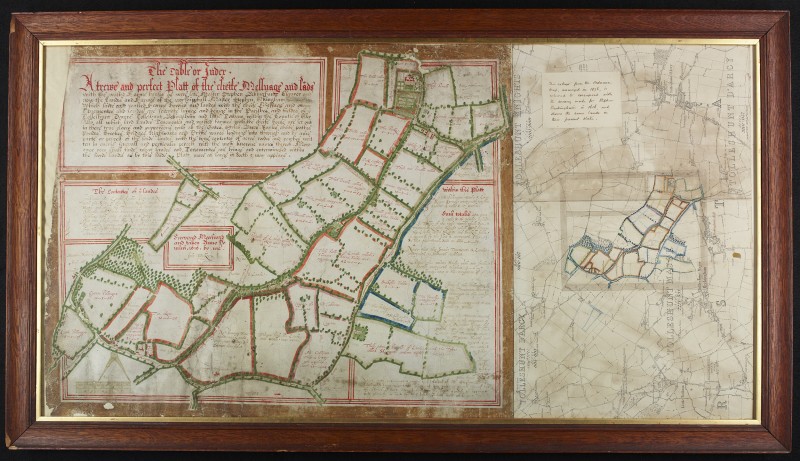
Richard Anderson, Archives and Collections Lead, writes: The survival, discovery and purchase of this map is of great importance to the Essex Record Office, which is indebted to the Friends of National Libraries for generously covering the full cost of its private purchase from the former owner.
In the 1960s the County Archivist of Essex, K.C. Newton, and his deputy, A.C. Edwards, wrote a lavish analysis of two Jacobean Essex cartographers, both called John Walker, which was later printed as The Walkers of Hanningfield: Surveyors and Mapmakers Extraordinary (Chelmsford, 1985). The Walkers produced during the period 1584 to 1628 some 35 beautifully coloured and surveyed unique maps. The maps are prized, in Newton and Edwards’ words, as “a corpus of outstanding Elizabethan and Jacobean estate maps by two gifted cartographers”, and more than half of the originals have come to be preserved at Essex Record Office in Chelmsford.
However, Newton and Edwards were at a loss to find any information about the whereabouts of the 27th in chronology of the 35 maps. It had not been seen since 1925 and all they could conclude was “Original now lost”. Made for the estate owner Stephen Beckingham, it was known to cover 266 acres in the two adjoining parishes of Tolleshunt d’Arcy and Tolleshunt Major, and to be characteristic of their colourful approach, but a black and white photocopy was all that was ever to be available for historians. It was wonderful therefore when in November 2020 it was revealed that the original map had been behind glass on the wall in the home of direct descendants of the Beckingham family and was now available for sale.
The colouring of the map has been remarkably well preserved given that it had hung on a wall for so long. As will be apparent from the image, at some point during the 20th century, part of an 1876 Ordnance Survey at 6 inches to the mile was framed with it. Usefully this has been marked with the field boundaries of the Walker map as they later appeared. The map has now been removed from its frame and the Ordnance Survey map retained with the original in a single encapsulation after conservation at the Essex Record Office, ensuring that the whole item is available for viewing on request in the searchroom for future users.
This map of Tolleshunt d’Arcy and Tolleshunt Major is not just an elegant artefact but a source for domestic architecture, cartographic history and local studies. The Essex Record Office intends to mark its acquisition through an article for the Friends of Historic Essex, as well as making the image available through Essex Archives Online. It is unlikely that the opportunity to acquire a map by John Walker will ever emerge again and it is thanks to FNL that it can be kept publicly and permanently available at the Essex Record Office.
